

Why does the 'Heart of Asia' lie in China's Urumqi?
- From the Heart of Asia to the Core Region on the Silk Road Economic Belt
Nicknamed the "Heart of Asia," Xinjiang Uyghur Autonomous Region has become the forefront of China's opening to the West since the Belt and Road Initiative was proposed ten years ago. It has played a crucial role in strengthening China's economic and trade ties as well as cultural communications with Central Asia and Europe.
"Heart of Asia" refers to the geographical center of the Asian continent. Thirty-one years ago, it was measured and announced to be located in Urumqi, the capital of Xinjiang, China, by the Chinese Academy of Sciences in collaboration with geographers overseas.
We visited the "Heart of Asia" landmark and its surrounding villages in the northern foothills of the Tianshan Mountains, which is the southern edge of the Junggar Basin. Based on this, we wrote this story in order to tell you why people searched for the "Heart of Asia", why it is in Urumqi, and how people have devoted themselves to construction of the "Capital of Heart of Asia."
A detailed story. (Approximately 5 minutes are needed to finish the story.)
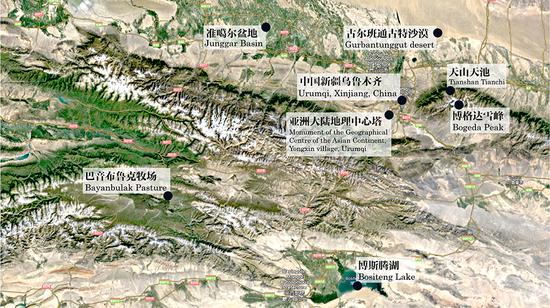
Asia is the largest continent in terms of land area. The geographical center of the Asian continent is located in the Yongxin village in Yongfeng Town, Urumqi County, approximately 30 kilometers southwest of the city of Urumqi.
More specifically, the "Heart of Asia" is marked by a monument of the geographical center (referred to as the "Tower of Heart of Asia"), which is located at the Square of the Heart of Asia in the Yongxin Village.
Built with reinforced concrete and fixed with granite tiles, the 22-meter-tall monument is supported by four square columns, on top of which rests a steel grid sphere with a diameter of 4 meters.
The monument has a miniature map of Asia at its base. A pendulum hung below the sphere points to the precise location of the geographical center of the Asian continent on the map: 87°19'52" E and 43°40'37" N (refer to Figure 1).

Why is the "Heart of Asia" located in Yongxin Village, Urumqi?
In short, it is the result of rigorous geographical measurement.
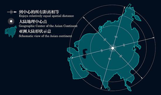
The work involves finding a location within the continent that is equidistant from all directions (refer to Figure 2).
As the Earth is spheroid, it is impossible to measure the distance between two locations on its surface directly with a ruler. Therefore, geographers need to get off by creating maps via projection methods to transform the three-dimensional spheroid Earth into a two-dimensional plane (refer to Figure 3).
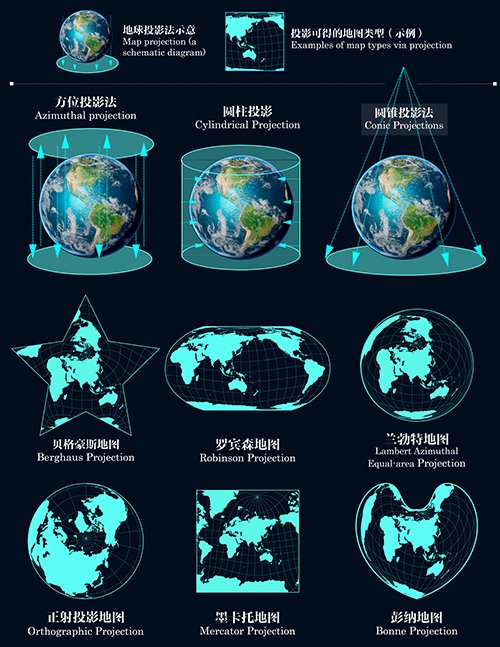
There are many projection methods, but none of them can restore the surface morphology of the Earth when transforming the three-dimensional globe into a two-dimensional map. Therefore, the map projection and calculation methods should be carefully decided to reduce errors in the measurement of the continent’s geographical center.
In 1992, the Xinjiang Institute of Ecology and Geography, Chinese Academy of Sciences announced that the geographical center of the Asian continent was located inYongxin Village, Urumqi County, with coordinates at 87°19'52" E and 43°40'37" N.
Dr. Yan Shun, the chief of the research team, recalls the measurement process. Two methods were used: computer image processing and physical suspension, which were repeated four times. It took nearly a year to finish the project (refer to Figure 4).
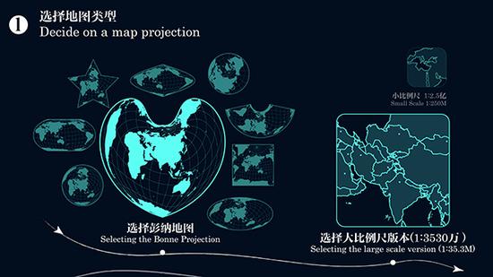
Step 1: Selecting an appropriate projection type.
The Asian continent is vast, with a long east-west distance and a lengthy coastline. For relative accuracy, the team selected the Bonne map projection, a large-scale pseudo-conical equal-area map projection method.
In contrast to small-scale maps, a relatively large-scale map presents clear continental details that help avoid errors in distance calculation.
Besides, the Bonne map projection’s heart-shaped graticule allocates all latitudes equally along the central meridians, which largely keeps the true area and shape of the Asian continent undistorted (refer to Figure 4a).
Step 2: Generating the shape of the Asian continent.
The team marked the boundaries of the Asian continent on the paper-print large-scale Bonne map, scanned it, and generated the shape of the Asian continent. And then, the shape was precisely divided into millions of pixel units.
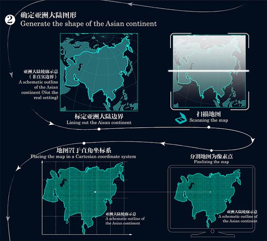
Step 3: Calculating the accurate location of the "Heart of Asia.
The pixelated continental shape was placed in a Cartesian coordinate system to calculate its central position.
The team converted the central position of the Asian continental shape into geographical coordinates, which referred to the geographical center. Based on the topographic map and satellite positioning device, the geo-coordinates further corresponded to the actual location, the location indicated by the pendulum of the “Heart of Asia” monument(refer to Figure 4c).

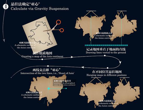
Step 4: Physical suspension method to verify the measurement of the "Heart of Asia."
The team created a map of Asia withthick paper, suspended it twice with different positions each time. A vertical line was drawn on the board each time after the paper stopped swinging.
The intersection of the two lines represents the center of gravity and the center of the paper. It can also be the geographical center of the Asian continent when converted into geographical coordinates. The result was later verified to match with the computer-aided measurement (refer to Figure 4d).
Why do we need to measure the geographical center of the Asian continent?
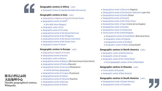
There is no universally acknowledged geographical center of continents due to the complexity of their geographical conditions and differences of measurements conducted by different countries.
However, the reputation of the geographical center of a place does help grow the local cultural, geographical, and tourism resources. Therefore, the measurement of the geographical center of a specific region is reportedly a common practice for geographers around the world, such as the geographical center of a continent, a country, or a state (refer to Figure 5).
The concept of the geographical center of the Asian continent is highly intriguing. Its surrounding areas have diverse landscapes, such as the northern foothills of the Tianshan Mountains at the southern edge of the Junggar Basin, which holds high value for tourism and scientific exploration.
The monument of "Heart of Asia" embodies good wishes for Asia (refer to Figure 7). Its structure is shaped like an “A,” the first letter of "Asia", and is designed to look like hands holding the Earth, which echoes the name -- “Heart of Asia.” The flags and maps of 48 Asian countries surrounding the monument and sculptures erected representing Asia cultures along the Totem Avenue, all implicate multicultural coexistence and interaction. The steel framework structure at the northern gate resembles a soaring eagle, symbolizing the prosperity of Asia.

The development of "Heart of Asia" tourism also benefits the local economy. Yongxin Village has undergone significant changes since the opening of the Heart of Asia geographical center attraction in 2003. The once remote village now has developed public transportation. Villagers increase their incomes by working in the tourism sector or running homestays or gardens for agrotourism.
As the "Capital of Heart of Asia," Urumqi is at the forefront of China's opening to the West
Being the “Heart of Asia”, Urumuqi enjoys great advantages with its location. With a beautiful belief in its future, it has become a vital gateway for China's westward opening-up, a key node in Xinjiang, the core region on the Silk Road Economic Belt, and an important transportation hub on the New Eurasian Land Bridge Economic Corridor.
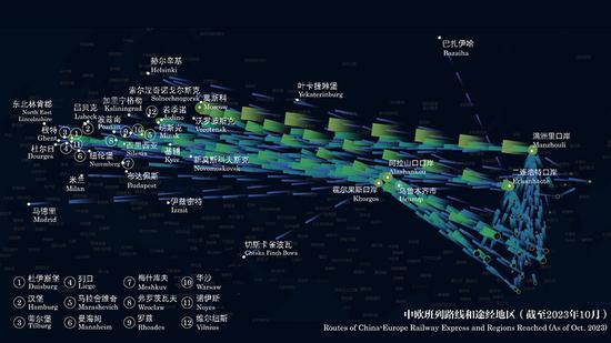
In May 2016, the hub of China-Europe Railway Express was established in the Xinjiang International Land Port. In the past five years, the hub has maintained an annual operation of over a thousand freight trains. As of now, more than 7,300 China-Europe (China-Central Asia) trains have been operated, transporting goods of over 200 different types to 19 countries and 26 cities across the Eurasian continent (refer to Figure 8).
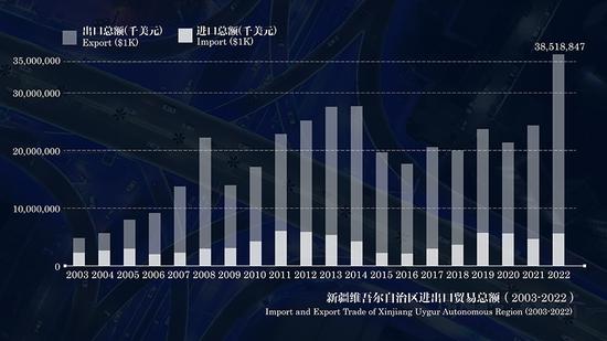
Since the Belt and Road Initiative was proposed ten years ago, Xinjiang Uyghur Autonomous Region has developed the Golden Corridor linking Asia withEurope, deepened international road transport cooperation, and achieved record-breaking foreign trade values (refer to Figure 9).
On November 1, 2023, the first pilot free trade zone in the remote regions of northwest China was established in Xinjiang. A total of 129 reformative pilot tasks will be conducted, including those to facilitate investment, enhance financial service functions, advance digital economic development, and strengthen talent services.
Xinjiang, as the geographical center of the Asian continent, has been developed into a new highland of reform and opening-up in the new era.
Epilogue
During our visit, the guide Yu Rui told us the story of Mr. Wu Tingde, the first keeper of the "Heart of Asia" monument.
In 1992, when the "Heart of Asia" was first announced, the monument was just wooden stakes, and Mr. Wu's house was located near the monument. Since then, Mr. Wu took care ofthe monument as he didwith his own house. Year by year, he dedicated himself to the maintenance work including weeding, wiping, rain shading, and ice-removing.
Unfortunately, he was later diagnosed with cancer. Despite his serious illness, he carved four 1-ton stone lions, hoping that they would serve as keepers of the monument after he passed away.
Looking around, Mr. Wu’s four stone lions are standing beside today’s towering monument, guarding the center of this massive continent. Through the passage of time, they remain silent and loyal.
Presented by: Chen Lujun
Supervisor: Zhang Mingxin
Chief Producer: Yu Lan
Producer: Wu Qingcai, Li Dehua
ExecutiveProducer: Peng Dawei, Ma Xueling, Yan Wenlu
Director: Ma Qian, Xu Yang, Zhang Jianyuan
Data storytelling: Ma Qian, Pan Qi, Gou Jipeng
Data visualization Design & development: Ma Qian
Filming: Zhao Kai
Photo: Pan Qi, Liu Xin
Motion Graphics: Song Xiaoyu
Narrator: Yang Yalong
Translator: Ma Qian
Proofreader: Feng Shuang, Wu Xinru, Chen Tianhao


 京公网安备 11010202009201号